Wednesday, 31 August 2016

Mount Riley

Hike Name: Mount Riley
Activity: Hiking
Distance: 9 km (RT)
Altitude: 536 m
Elevation Gain: 500m
Area: Chilkat State Park (Haines, AK)
Crew: Pouyan
Time to Summit: ~1.5 hours
Trailhead: Mud Bay Road Trailhead

Additional Info:
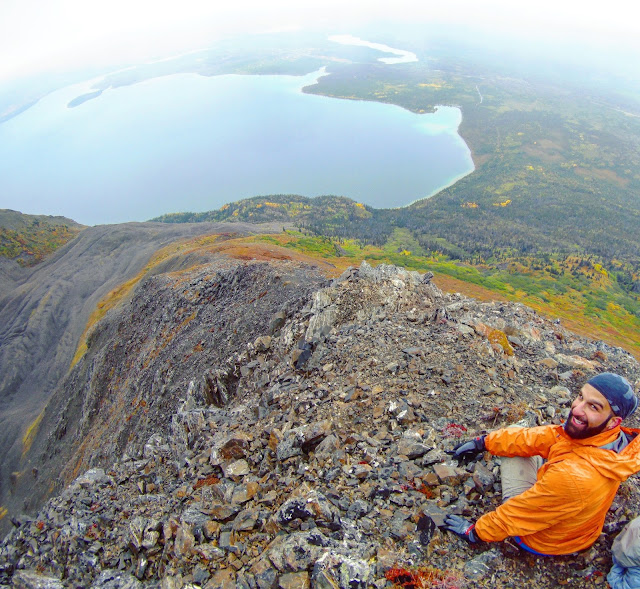
After arriving in Haines, Alaska, Pouyan and I headed straight to Haines Brewery, of course. After that, we did a beautiful coastal hike to the highest point on the Chilkat Peninsula, Mount Riley.
 Looking towards Haines, Alaska and the valley we drove in on the left.

 Pouyan and the H2O! Waterway to Skagway on the right.

Such a unique view vs. the views that I am used to in the Rockies! 

Summit Selfie!

Tuesday, 30 August 2016

King's Throne

Hike Name: King's Throne Summit
Activity: Hiking/Scrambling
Distance: 15km (RT)
Altitude: 2,006 m
Elevation Gain: 1250m
Area: Kluane National Park (Yukon)
Crew: Pouyan
Time to Summit: N/A
Trailhead: Kathleen Lake

Getting There:
Drive South from Haines Junction ~60km until you see the turn off for Kathleen lake. The trail head is ~50m before the actual lake parking area.

Additional Info:
Pouyan and I left Whitehorse early in the morning and arrived at Haines Junction and Kluane National Park, only to find the mountain tops hidden by a low ceiling. We decided to tackle King's Throne anyways, and once we reached the clouds we soaked in the view & turned around.
 A+ Team Selfie

Pouyan and fall colours!

Monday, 29 August 2016

Grey Mountain

Hike Name: Grey Mountain
Activity: Hiking
Distance: 5 km (RT)
Altitude: ~1,500 m
Elevation Gain: 250m
Area: Whitehorse (Yukon)
Crew: Pouyan
Time to Summit: ~1 hour
Lisa's Mom Rating: Yes
Trailhead: End of Grey Mountain Road by the Comms Towers

Additional Info:
After arriving in Whitehorse, Pouyan and I did a nice afternoon hike while we waited for Mike to get off of work! The best part of this hike is that you do 80% of the elevation gain via car, so it is an enjoyable hike through the alpine.
 View of the summit from the trailhead

Hanging out, facing Whitehorse below 

 Back at the car

Saturday, 27 August 2016

Moose Mountain Trail Race

Activity: Trail Running
Distance: 29km (RT)
Altitude: 2,437 m
Elevation Gain: ~1000m
Area: Bragg Creek (Kananaskis)


Mom and I at the finish line

Sunday, 21 August 2016

Bow Peak


Hike Name: Bow Peak
Activity: Hiking/Scrambling
Distance: 14.7km (RT)
Altitude: 2,879 m
Elevation Gain: 950m
Area: Banff (Icefields Parkway)
Crew: Travis, Zach
Time to Summit: 3 hours
Lisa's Mom Rating: Maybe
Trailhead: ~500m south of the Crowfoot Glacier Viewpoint, there is a pullout on the southbound side of the road.

Getting There:
From the Trans-Canada (Hwy 1), head north on the Icefield Parkway (Hwy 93). Continue about 30 km. It may be best to go to the Crowfoot Glacier Viewpoint then turn around and backtrack 500m to the pullout.

Additional Info:
On the first day of the summer with 0% chance of rain in the forecast (note its AUGUST 21 and leaves are turning yellow..), we decided to head out to the Icefields Parkway. We settled on Bow Peak because we brought Travis' dog, Zach. This was an awesome hike, definitely worth even just going to Crowfoot pass. Once we hit the pass, we started heading left, up Bow Peak. There's some scrambling on boulders, then a nice ridge walk to the summit.
Note: You have to ford a creek early on in the hike. The water was mid-thigh height on me in the afternoon. 
 Bow peak (left) from the trailhead / Hwy 93

 View through the pass towards the mountains bordering Hwy 93. Temple is seen in the distance (middle)

 Hector lake

 Zach enjoying the view. And getting antsy to keep moving around! Mount Hector can be seen with the glacier in the middle background.

 Me trying to learn how a flag works (found in summit register!). Mount Balfour with the glacier in the background.

Heading down - Zach is ready to get a move-on again! You can see how far we hiked in, with Hwy 93 on the far right. The bottom of the closer lake is where we forded the creek.

Sunday, 14 August 2016

Mist Mountain


Hike Name: Mist Mountain
Activity: Hiking/Scrambling
Distance: ~12km (RT)
Altitude: 3,143 m
Elevation Gain: 1,330m
Area: Kananaskis Valley
Crew: Travis
Time to Summit: 3 hours
Lisa's Mom Rating: No
Trailhead: ~600m south of the Mount Lipsett Trailhead, there is a shoulder area to park on the northbound side of the road.

Getting There:
From the Trans-Canada (Hwy 1), head south on Kananaskis Trail (Hwy 40). Continue past the turnoff to the Smith-Dorrien. The trailhead is about ten minutes past Ptarmigan Cirque.

Additional Info:
We went for round 2 with this mountain and hit the summit + warm springs! After our first attempt on Mist, we would have been heart broken to have to slog back in a third time. It was a gorgeous day - we were the first ones on the summit, hit the warm springs on the way down, and made it back to the car just 5 minutes AFTER huge storm rolled in. So our timing today was almost perfect!
ps. My legs were still dead from the Temple/Moose Mountain day.. Mist was a struggle for me!
 View of the summit from the Mist Outlier. Just a quick ridge traverse from here to the summit.

 Looking north from the summit

 Looking south from the summit

 Me on the summit ridge

 Kicking the feet up for a nice lunch view on the summit

 Cool warm springs!

The best way to end a hike.. if only this was on every mountain.

Friday, 12 August 2016

Moose Mountain ii


Hike Name: Moose Mountain
Activity: Trail Running
Distance: 14.6 km (RT)
Altitude: 2,437 m
Elevation Gain: 470 m
Area: Kananaskis (Bragg Creek)
Crew: Mom, Lianne, Donovan, Jason
Time to Summit: 1:20
Lisa's Mom Rating: Yes

Trailhead: Moose Mountain Parking

Getting There:
Once you have passed Bragg Creek going south, you will come to a T intersection. Turn right onto highway 66 towards Elbow Falls (West). Take the turn-off for Moose Mountain on the right and continue up the road until you can go no further.

Additional Info:
After summiting Mount Temple earlier this day, I was pretty damn wary about whether I would be able to do this trail run. BUT I promised my mom I would go with her, and she invited a bunch of her trail running friends, so I just couldn't let her down. I ended up being able to do it just fine (I have NO idea where that energy came from!), and we had an awesome trailrun up Moose Mountain!


I've hiked up Moose Mountain before too.


Note: This trail is open year-round, but there is a gate in front of Moose Mountain Road from December 1 to May 14 every year. You will have to hike an additional 7 km (one-way) to the above trailhead.
 Group heli-pad/summit pic


 Looking out into the mountains


So happy to lie down.. only 7 km to go.

Mount Temple


Hike Name: Mount Temple
Activity: Scrambling
Distance: 16km (RT)
Altitude: 3,544 m
Elevation Gain: 1690m
Area: Banff (Lake Louise)
Crew: Matt, Kevin
Time to Summit: ~4:00 moving time
Lisa's Mom Rating: No
Trailhead: Moraine Lake

Getting There:
Heading west on the Trans Canada (Hwy 1), take the exit into the town of Lake Louise. Continue straight through the stop sign, then you will turn left onto the Moraine lake road and drive along this for ~15 minutes.

Additional Info:
We hiked up Sentinel pass to watch the Perseid meteor shower and stars. The next day, we were on the summit of Mount Temple at 10AM! Sadly, half of the view was obscured by clouds but we could still somewhat see the valley of the ten peaks and over towards Lake Louise. We tried to wait out the clouds but they didn't end up clearing, so we headed back down to the parking lot and were onto our next adventures...
 Me and Kevin scrambling on Temple

 Summit Push! (Photo by Matt Hill)

 Valley of the Ten Peaks from the summit push

 Looking towards Eiffel.. it looks so small!

 Obligatory summit-gopro-selfie

Sharing the summit with some little friends!

Tuesday, 9 August 2016

The Rockwall Trail (Overnight)


Name: The Rockwall Trail
Activity: Backcountry Camping/Backpacking
Total Distance: 61 km
# Nights: 3
Date: August 6-9, 2016
Area: Kootenay National Park
Crew: Ben, Eric, Travis, Stephen
Trailhead: Floe Lake Trailhead / Paint Pots Trailhead


Route: 
Day 1 - Floe Lake Trailhead to Floe Lake Campground (10km, 700m)
Day 2 - Floe Lake Campground to Tumbling Creek Campground (17.5km, 1100m)
Day 3 - Tumbling Creek Campground to Helmet Falls Campground (12.5km, 400m)
Day 4 - Helmet Falls Campground to Paint Pots Trailhead (14.7km, -400m)


We did the Rockwall Trail in Kootenay National Park from South to North. We ended up having to rent a 4-man tent since Bennett's work schedule lined up with our trip (yay)! The tent pads were plenty large enough for a 4-man and could most likely accommodate a 6-man (which we contemplated borrowing from JJ...)


Our plan was to do 2 side-trips - Numa Mountain and Goodsir Pass - we didn't end up doing either! It was too rainy on the first afternoon to enjoy summiting a mountain. Then on the third day we were going to hike up to Goodsir Pass, but we ran out of time because we took our time enjoying the hike from Tumbling to Helmet - we stopped for 2 hours to enjoy the sun and do some acro-yoga with Eric on Wolverine Pass, then also side-tripped up an unofficial peak "Drysdale NE4". Once we arrived at Helmet, we did the ~2km (RT) hike up to Helmet Falls

Overall this was an unreal trip. The weather was forecasted to rain most of the time, but we only had to hike in the rain for ~30mins on Day 2, and although it rained 2/3 nights, we never had to cook in the rain and we kept our tent/sleeping bags dry. The last day was by far the most weather-consistent so we were sad to leave the Rockwall Trail and go back to civilization.

Floe Lake reflection after some rain (Day 1)

Hiking up on the moraines across Floe Lake at sunset (Day 1)


 Beautiful wildflowers that we got to see every day! (Day 2)

Coming down from Numa Pass (Day 2)

Lush forest common along the trail at valley bottoms (Day 2)

Group selfie (Day 2)

Tumbling Glacier (Day 2)

View of Helmet Falls from the campsite (Day 3)

 Helmet Creek Patrol Cabin (Day 4)