Showing posts with label Ridge. Show all posts
Showing posts with label Ridge. Show all posts
Sunday, 14 June 2020

Saturday, 6 July 2019
Monday, 31 December 2018
Sunday, 28 October 2018
Kalepa Ridge
 Hike Name: Kalepa Ridge
Activity: Hiking
Distance: ~5 km (RT)
Altitude: 1,219 m
Elevation Gain: 176 m
Area: Kauai (HI, USA)
Crew: Steph
Time to End: ~1 hrs
Lisa's Mom Rating: Yes
Trailhead: Kalalau Lookout, Koke'e State Park
Additional Info:
Steph and I were recommended to do Kapela Ridge as one of our first hikes. The weather was beautiful and hot, the clouds were rolling in and out, dramatically changing the scenery as we hiked. After we finished Kalepa Ridge, we did the Canyon Trail in the Waimea Canyon. We did get some BEAUTIFUL ocean views, even though I don't have them pictured here.

Always snappin' pics

A candid Steph, framed nicely!!

Beautiful.
Monday, 23 July 2018
Northover Ridge (Overnight)
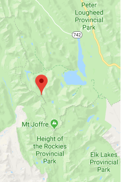 Name: Northover Ridge
Activity: Backcountry Camping/Backpacking
Total Distance: 41 km
# Nights: 2
Date: July 21 - July 23, 2018
Area: Kananaskis Lakes
Crew: Ben, Mark, Laura
Trailhead: Interlakes
Trailhead: Interlakes
Day 1 - Interlakes to Aster Lake (14km, ~600m) +3km because we missed a turn (so deep in conversation that we went 1.5km without noticing!)
Day 2 - Aster Lake to Three Isle Lake via Northover Ridge (13km, ~950 total)
Day 3 - Three Isle Lake to Interlakes (11km, all downhill, baby)
Northover Ridge has been on the top of our list for a looooong time. We have been talking about it for a few years, and booked it for September 2017 but had to cancel due to a snowstorm and hiked into Assiniboine instead. We finally got it booked for the summer of 2018 and we crossed our fingers for nice weather.
I'll start talking about booking - book 90 days in advance from the first day of your trip - they are strict. We emailed them at 9am on the 90-day-prior-mark and didn't get one of the 5 tent pads at Aster for the Friday night, so we shifted our trip by 1 day (Saturday to Monday instead) and booked right at midnight to get in. This was actually for the best, since on our hike in, everyone we talked to who had done the ridge said it was insanely windy - including on Saturday (the day we originally planned to do the ridge). Luckily, our ridge day - Sunday - had little to no wind and no rain/snow! We were beyond stoked. Of course.
The first day was pretty funny, as we were all head-down, chatting, following each other and kept missing turns. At one point we walked 1.5km in the wrong direction (at least it was flat!) and had to double back so we tacked 3km onto our day.... nice warmup, right??... right. The trail to hidden lake was a little tough to find (with our heads down & hearts in the middle of the now, as Bennett would say) but once we found it, it was quite obvious and a well-beaten track. I'll point out that the trail in the trees around Hidden Lake is solid too - as older trip reports say it is a bushwhack - it is not anymore.
Aster Lake Campground is a beautiful little spot. We met a guided group who had just summited Joffre that day and also ran into some friends at Aster Lake - which is hilarious, considering it is probably the smallest campground in Kananaskis (with 5 tent pads)! We ate some delicious backcountry tacos for dinner - not even dehydrated - thanks for carrying 2 lbs of raw meat in, Laura! We had also read about a porcupine infestation on previous trip reports and they were the butt of the jokes for the weekend - so we were diligent about hanging our packs and hiding our boots in our vestibules - and were looking forward to laughing at the porcupine shrieks in the middle of the night - but that didn't happen... so update: seems that there are no more porcupine at Aster Lake! Haha.
The next day we hiked Northover Ridge to Three Isle Lake. And what a day it was! The photos will speak for themselves (below), but it was a stellar day with pretty ideal weather. We all agreed that this is the best backcountry trip we have ever done in Alberta/BC. The boys went for a dip in Three Isle lake, we played Shithead (which Mark remained undefeated in?????), then called it a night (at 9:30... bunch'a night owls).
Get ready for a photo overload...!

Making our way to Aster Lake (Day 1)

Laura (Day 1)

U wot m8? (Day 1)

One of the few scramble sections on the way to Aster (Day 1)

The entire Aster Lake Campground in 1 pic. Seriously beautiful spot. (Day 1)

The most scenic outhouse. (Day 1)

Walking towards Aster Lake. Mount Warrior in the middle background (Day 2)

Tight on the left path around Aster Lake (Day 2)

HI MOM (Day 2)

Joffre, Bennett, Warrior. (Day 2)

Laura walking towards the pass we have to ascend soon (just right of Center, Day 2)

..and the Tarns, which you can random-camp at (they are in BC, Day 2)

Bennett, Joffre. (Day 2)

3 studs. (Day 2)

A group close behind us (Day 2)

A group not too far ahead of us (Day 2)

Group pic before dropping down towards Three Isle (Day 2)

Mark and the huge landscape (Day 2)

Dropping in towards Three Isle, which can be seen at the end of the valley (Day 2)

Crew still cruisin' (Day 2)

Dinner with a view (Day 2)

Heading back to reality! (Day 3)
Sunday, 6 May 2018
Opal South Peak ii
Trip #2:
Crew: Bennett, Steph, Pouyan
Date: May 6, 2018
Time to Summit: 2:00
Click here for the Opal Ridge South Post


Crew: Bennett, Steph, Pouyan
Date: May 6, 2018
Time to Summit: 2:00
Click here for the Opal Ridge South Post

Ben & PK. Summit on the right

Still winter back here!

Nearing the summit

Steph & I

PK!!

chillin.


Group pic!
Sunday, 18 March 2018
Tent Ridge (Winter)
 Name: Tent Ridge
Activity: Alpine Touring/Backcountry Skiing
Distance: ~7 km
Altitude: ~2,500 m
Elevation Gain: ~800 m
Area: Kananaskis (Spray Valley)
Crew: Bennett
Time to Summit: ?
Getting There:
Head south on Kananaskis Trail (Hwy 40) from the Trans Canada (Hwy 1). Take the turnoff toward the Kananaskis Lakes/Smith-Dorrien. Take the Smith Dorrien and then turn at the Mt. Engadine Lodge turnoff. Continue past the lodge, and up the road. You will come across a parking area on the right.
Additional Info:
We were on our way back from Canmore for the weekend and were trying to decide what to do. We cross country skiied at Pipestone Loop the previous day and wanted to go for a tour. We were debating between Burstall Pass and Tent Ridge and decided to do Tent Ridge, as the avi forecast was quite low this day and there wasn't much risk of solar warming as it was cloudy. We were planning on staying in the trees if the visibility remained poor but with good conditions, we made our way a little ways up the shoulder on the left and did two laps. We got a few very brief bouts of sun, the day mostly consisted of clouds moving in/out to obscure visibility. There was another group on the mountain this day, skiing the same left-hand side of the bowl, as well as 2 groups skiing the right-hand side.

Staring to clear up

Our turnaround point

Cool shots in the clouds

"Bennett take photos of me tooooo"

Can you spot Bennett among the trees? (Probably not because he blends right in with his black outfit...)

Best snack ever.

Snowwwww

Heading up through the trees.
Monday, 19 June 2017
Raspberry Ridge
 Hike Name: Raspberry Ridge
Activity: Hiking
Distance: ~10 km (RT)
Altitude: 2,373 m
Elevation Gain: ~646 m
Area: South Kananaskis
Crew: Travis, Zach
Time to Summit: ~2 hours
Lisa's Mom Rating: Yes
Trailhead: Pullout on the side of Hwy 940
Getting There:
Head south on Cowboy Trail (Hwy 22) from Calgary. In Longview, take the right turn onto Kananaskis Trail (Hwy 40). Turn south/left onto Hwy 940 and park in the unmarked gated road about 11.4 km south of the Hwy 40/Hwy 940 intersection (west side of the road).
Additional Info:
We were going to have dinner at Travis' mom's house with Jaimie and JJ (before they both moved away) and decided to hike down in the Longview area. This is a great trail for anyone who would like nice views in the South Kananaskis area. Beautiful views, easy trail to follow, and there is a fire lookout at the top.

Fire lookout on top of Raspberry Ridge

Most scenic outhouse.

Looking back.
Saturday, 28 January 2017
Red's Ridge
 Hike Name: Red Ridge
Activity: Hiking/Snowshoeing
Distance: ~9 km (RT)
Altitude: 2,610 m
Elevation Gain: ~700 m
Area: Kananaskis (Spray Valley)
Crew: Bennett
Time to Summit: did not summit
Lisa's Mom Rating: Yes
Trailhead: Sparrowhawk Parking
Getting There:
Head west from Calgary on the Trans Canada (Hwy 1). Go south at Canmore (toward the Nordic Center) and take highway 742 until you reach the Sparrowhawk parking area.
Additional Info:
Bennett and I got out for a winter snowshoe, unfortunately we didn't hit the summit, as we had to get back to the city to make it home in time for plans.

Bennett on our way up

Looking up the Spray Reservoir

Where we turned around

A handsome hiker
Subscribe to:
Posts (Atom)