Friday, 12 August 2016

Moose Mountain ii


Hike Name: Moose Mountain
Activity: Trail Running
Distance: 14.6 km (RT)
Altitude: 2,437 m
Elevation Gain: 470 m
Area: Kananaskis (Bragg Creek)
Crew: Mom, Lianne, Donovan, Jason
Time to Summit: 1:20
Lisa's Mom Rating: Yes

Trailhead: Moose Mountain Parking

Getting There:
Once you have passed Bragg Creek going south, you will come to a T intersection. Turn right onto highway 66 towards Elbow Falls (West). Take the turn-off for Moose Mountain on the right and continue up the road until you can go no further.

Additional Info:
After summiting Mount Temple earlier this day, I was pretty damn wary about whether I would be able to do this trail run. BUT I promised my mom I would go with her, and she invited a bunch of her trail running friends, so I just couldn't let her down. I ended up being able to do it just fine (I have NO idea where that energy came from!), and we had an awesome trailrun up Moose Mountain!


I've hiked up Moose Mountain before too.


Note: This trail is open year-round, but there is a gate in front of Moose Mountain Road from December 1 to May 14 every year. You will have to hike an additional 7 km (one-way) to the above trailhead.
 Group heli-pad/summit pic


 Looking out into the mountains


So happy to lie down.. only 7 km to go.

Mount Temple


Hike Name: Mount Temple
Activity: Scrambling
Distance: 16km (RT)
Altitude: 3,544 m
Elevation Gain: 1690m
Area: Banff (Lake Louise)
Crew: Matt, Kevin
Time to Summit: ~4:00 moving time
Lisa's Mom Rating: No
Trailhead: Moraine Lake

Getting There:
Heading west on the Trans Canada (Hwy 1), take the exit into the town of Lake Louise. Continue straight through the stop sign, then you will turn left onto the Moraine lake road and drive along this for ~15 minutes.

Additional Info:
We hiked up Sentinel pass to watch the Perseid meteor shower and stars. The next day, we were on the summit of Mount Temple at 10AM! Sadly, half of the view was obscured by clouds but we could still somewhat see the valley of the ten peaks and over towards Lake Louise. We tried to wait out the clouds but they didn't end up clearing, so we headed back down to the parking lot and were onto our next adventures...
 Me and Kevin scrambling on Temple

 Summit Push! (Photo by Matt Hill)

 Valley of the Ten Peaks from the summit push

 Looking towards Eiffel.. it looks so small!

 Obligatory summit-gopro-selfie

Sharing the summit with some little friends!

Tuesday, 9 August 2016

The Rockwall Trail (Overnight)


Name: The Rockwall Trail
Activity: Backcountry Camping/Backpacking
Total Distance: 61 km
# Nights: 3
Date: August 6-9, 2016
Area: Kootenay National Park
Crew: Ben, Eric, Travis, Stephen
Trailhead: Floe Lake Trailhead / Paint Pots Trailhead


Route: 
Day 1 - Floe Lake Trailhead to Floe Lake Campground (10km, 700m)
Day 2 - Floe Lake Campground to Tumbling Creek Campground (17.5km, 1100m)
Day 3 - Tumbling Creek Campground to Helmet Falls Campground (12.5km, 400m)
Day 4 - Helmet Falls Campground to Paint Pots Trailhead (14.7km, -400m)


We did the Rockwall Trail in Kootenay National Park from South to North. We ended up having to rent a 4-man tent since Bennett's work schedule lined up with our trip (yay)! The tent pads were plenty large enough for a 4-man and could most likely accommodate a 6-man (which we contemplated borrowing from JJ...)


Our plan was to do 2 side-trips - Numa Mountain and Goodsir Pass - we didn't end up doing either! It was too rainy on the first afternoon to enjoy summiting a mountain. Then on the third day we were going to hike up to Goodsir Pass, but we ran out of time because we took our time enjoying the hike from Tumbling to Helmet - we stopped for 2 hours to enjoy the sun and do some acro-yoga with Eric on Wolverine Pass, then also side-tripped up an unofficial peak "Drysdale NE4". Once we arrived at Helmet, we did the ~2km (RT) hike up to Helmet Falls

Overall this was an unreal trip. The weather was forecasted to rain most of the time, but we only had to hike in the rain for ~30mins on Day 2, and although it rained 2/3 nights, we never had to cook in the rain and we kept our tent/sleeping bags dry. The last day was by far the most weather-consistent so we were sad to leave the Rockwall Trail and go back to civilization.

Floe Lake reflection after some rain (Day 1)

Hiking up on the moraines across Floe Lake at sunset (Day 1)


 Beautiful wildflowers that we got to see every day! (Day 2)

Coming down from Numa Pass (Day 2)

Lush forest common along the trail at valley bottoms (Day 2)

Group selfie (Day 2)

Tumbling Glacier (Day 2)

View of Helmet Falls from the campsite (Day 3)

 Helmet Creek Patrol Cabin (Day 4)


Monday, 8 August 2016

Drysdale NE4


Hike Name: Drysdale NE4
Activity: Hiking
Altitude: ~2,400 m
Area: Kootenay (The Rockwall)
Crew: Travis, Stephen, Bennett, Eric

Getting There:
See the link below in "Additional Info".

Additional Info:
While we were on Day 3 of the Rockwall Trail on Rockwall Pass, we saw the opportunity to go up to a ridge and get a better view of the Rockwall and surrounding peaks (and bag a peak since we missed Numa the other day!). The weather rolling in behind us looked ominous so we stopped at a highpoint on the ridge and turned back - but it surprisingly stayed where we saw it (over Wolverine Pass), and it didn't rain all night!
 Travis, Eric and Bennett coming up the ridge

 Me and Bennett

 Bennett and the view behind towards Helmet Falls Campground. The Rockwall is seen on the left.

The clouds that looked menacing but stayed put.

Sunday, 31 July 2016

Cascade Mountain

Hike Name: Cascade
Activity: Hiking/Scrambling
Distance: ~19km (RT)
Altitude: 2,998 m
Elevation Gain: 1381m
Area: Banff (Town)
Crew: Crescent Point Hike
Time to Summit: 4:00
Lisa's Mom Rating: No
Trailhead: Mount Norquay Ski Lodge

Getting There:
Heading west on the Trans Canada (Hwy 1), continue past the town of Banff, then take the turnoff on the right towards Mount Norquay. This roads winds up towards the ski hill for 6km, and the hike starts from the first parking lot at the lodge.

Additional Info:
This hike was organized by my work - so at 9AM we set off from the Mount Norquay Ski Lodge, heading to the Cascade Amphitheater, where some stayed behind to relax while the rest of us scrambled to the peak.
 This cloud was stuck to the peak for quite a white, obscuring the view of Banff.

 Summit photo looking towards the mighty Mount Assiniboine

 Me on the summit

The cloud cleared off on our way down. Banff town on the bottom right, and Rundle Mountain directly ahead.

Friday, 29 July 2016

Mount Sparrowhawk

Hike Name: Mount Sparrowhawk
Activity: Hiking/Scrambling
Distance: 10km (RT)
Altitude: 3,121 m
Elevation Gain: 1350m
Area: Kananaskis (Spray Reservoir)
Crew: Julia, Travis
Time to Summit: 3:30
Lisa's Mom Rating: No
Trailhead: Sparrowhawk parking area

Getting There:
From the town of Canmore, head towards the Nordic center and take the gravel road, the Smith Dorrien (742), about half-way down the Spray Reservoir. Park at the Sparrowhawk parking area.

You can also come from Kananaskis Trail (Hwy 40), taking the turn towards the Kananaskis Lakes then turning onto the Smith Dorrien (742). If you are coming from Calgary, it is faster through Canmore.

Additional Info:
We did this as a sunset hike after-work. It was definitely an ambitious goal but we ended up doing it no problem. We left the car at 5 PM, summited at 8:30 PM, took a half-hour long break to admire the view, and then returned to the car by 11:15 PM.

The views were unreal from the summit, true 360 degrees. You could easily see Assiniboine, and even Joffre off in the distance to the south. On a clearer day I'm sure you could see Calgary.

We followed a GPS track that I had on my phone, which was someone's bushwhack trail. Apparently there is a better trail - I am assuming you should go up Read's Tower trail instead, and branch off towards Sparrowhawk at the bottom of the bowl. The bushwhack wasn't a problem on the way up but we weren't sure how to tackle the bushwhack in the dark on the way down, so we decided to follow the creek down to the road. It eventually turned into a canyon, so we followed the creek/canyon on the skiier's right, and made it back to the road in no time.
Julia coming up the final scramble behind the summit block

 Unreal summit view

 Travis on the summit ridge

 The three mountains just left of center that are taller than the rest - Eon, Aye and Assiniboine (left to right)

Mountain shadows as the sun sets behind.. 

 Beautiful sunset shot

Me on Sparrowhawk

Saturday, 23 July 2016

Crypt Lake


Hike Name: Crypt Lake Trail
Activity: Hiking
Distance: 17.4km (RT)
Altitude: 1,996 m
Elevation Gain: 700m
Area: Waterton
Crew: Julia, Steph, Christine, Shahir, Jay, JJ, Trevor
Time to Lake: 2 hours
Lisa's Mom Rating: Yes
Trailhead: Waterton Ferry Port

Getting There:
Go to the Ferry Port in Waterton


Additional Info:
This is a very popular hike in Waterton National Park. We caught the 8AM ferry in town and after about 15 minutes, we were at Crypt Landing, the trailhead for the Crypt Lake Hike. The path is obvious and easy to follow. The first half of the hike is through a lush forest, and the view open up during the second half of the hike. There is a section with a ladder, tunnel, and chain bolted to the side of the mountain, which added to the experience of this trip! We spent about an hour and a half at the lake before heading back down.

 The final set of falls before the lake. Viewed from just after the tunnel.

 Relaxing at Crypt Lake

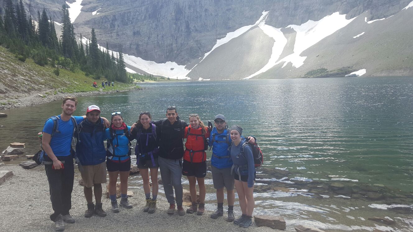
Team photo at Crypt Lake