Thursday, 30 June 2016

Alderson Lake (Overnight)


Hike Name: Alderson-Carthew Trail / Alderson Lake Overnight (Attempt)
Activity: Backcountry Camping/Backpacking
Total Distance: 23 km
# Nights: 1 0
Date: June 30 - July 1, 2016 June 30, 2016
Area: Waterton
Crew: Ben
Trailhead: Cameron Lake (free shuttle from Waterton Townsite to Alderson-Carthew trailhead). Hike through to Waterton Townsite


PLANNED Route: 
Day 1 - Cameron Lake to Alderson Lake (peak bag Mount Alderson on the way) (15km)
Night 1 - Alderson Lake Backcountry Campground
Day 2 - Summit Mount Carthew and Buchanan Peak then hike out to Waterton Townsite (7-10km)


We ditched our backpacks near the summit pass and took our day packs to peak-bag Mount Alderson. This would have been a leisurely and straight-forward hike to the summit, however we ran into a black bear ~1/2 way up and had to desert our attempt.
We grabbed our packs and continued down to Alderson Lake to set up our camp. After relaxing, re-filling water, and setting up our tent, we were ready to make dinner. However, the other couple at the campsite mentioned to us that one or two black bears had been poking around the campsite for an hour. We noticed there was a half-eaten package of beef jerky left at the food-prep area and wondered whether the bears have been eating the garbage left at the campground. We decided to pack up our tent and slog back into town (mainly because I was nervous).
We basically did complete our backpacking trip, just fast-forwarded through the sleeping portion and hiked out on the same day...


ACTUAL Route:
Day 1 - Cameron Lake to Alderson Lake (Mount Alderson attempt on the way). Set up at Alderson Lake Backcountry Campground for a few hours but pack up due to a black bear poking around for a while, hike through to Waterton Townsite. (23 km)
Night 1 - Thirsty Bear and sleep in Bennett's truck!


 Me and Bennett on our way up to the summit pass
 Beautiful colours on Mount Alderson (right)
 Bennett and a nice waterfall
Alderson Lake and Bennett


Wednesday, 29 June 2016

Bear Hump


Hike Name: Bear Hump
Activity: Hiking
Distance: 2.8 km (RT)
Altitude: 1,546 m
Elevation Gain: 225m
Area: Waterton
Crew: Ben
Time to Summit: 20 minutes
Lisa's Mom Rating: Yes
Trailhead: Waterton Visitor Center

Getting There:
Heading into Waterton, park at the Parks Canada visitor center.

Additional Info:
Bennett and I had a lovely sunset hike up the Bear Hump. We arrived in town around 8pm and after we set up camp (aka parked Bennett's truck), we decided to take a bottle of wine to the Bear Hump and watch the sunset.
 Bennett
Bennett and I

Sunday, 26 June 2016

Tunnel Mountain

Hike Name: Tunnel Mountain
Activity: Trail Run
Distance: 4.3 km (RT)
Altitude: 1,692 m
Elevation Gain: 300m
Area: Banff (Townsite)
Crew: Solo
Time to Summit: 20 minutes
Lisa's Mom Rating: Yes
Trailhead: North side of St. Julien Road

Getting There:
Heading into Banff town from the Trans-Canada (Hwy 1), take the Main Street entrance. Turn left onto Moose street. Eventually it will turn right and split into Grizzly Street and St. Julien Road. Take St. Julien Road and the parking lot will be on the left.

Additional Info:
I was visiting my Aunt in Banff for the weekend with my family. We were planning on going to Johnston's Canyon after breakfast so I decided to get up for the sunrise and then do a quick jaunt up Tunnel Mountain since I have never done it before.
 Sunrise from the third Vermilion Lake
About 50,000 cairns on the summit of Tunnel

Saturday, 25 June 2016

Wind Ridge

Hike Name: Wind Ridge
Activity: Hiking
Distance: 12.0 km (RT)
Altitude: 2,202 m
Elevation Gain: 781m
Area: Bow Valley (Dead Man's Flats)
Crew: Jay
Time to Summit: 2 hours
Lisa's Mom Rating: Yes
Trailhead: Near the Banff Gate Mountain Resort

Getting There:
Head west on the Trans-Canada (Hwy 1), take the exit on the right into Dead Man's Flats. Take the overpass over the highway and follow the road up the hill until you reach a parking lot on the right.

Additional Info:
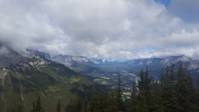
Jay and I enjoyed this moderately-sloped hike. The views are stunning - you can see Pigeon, Centennial Ridge, Lougheed, Windtower, Rimwall, as well as the town of Canmore, the Three Sisters, and the view East into the prairies.

Note: This area is closed from December 1 - June 15 annually for protection of elk and bighorn sheep.
Great view from near the top of Wind Ridge.
Me on an outcrop at the summit
Jay and the clouds on the summit
Looking towards Canmore from the summit

Tuesday, 21 June 2016

Mount Yamnuska iv


Trip #4:
Crew: Julia, Jaimie
Date: June 21, 2016
Time to Summit: 2:20

Click here for the Mount Yamnuska Page

We went out to Yamnuska after work on a Tuesday for a nice sunset hike. I know Yam is a popular hike but for a Tuesday evening we surprisingly (to me), we ran into another ~12 people on the mountain! Felt like a Saturday afternoon.


 Jaimie on the chain section
 Julia on the chain section
 Me on the summit
Nice view, looking up at Yam on the way back to the car

Sunday, 12 June 2016

The Wedge

Hike Name: The Wedge
Activity: Scrambling
Distance: 8.1 km (RT)
Altitude: 2,667 m
Elevation Gain: 1035m
Area: Kananaskis Valley
Crew: Julia
Time to Summit: 2.5 hours
Lisa's Mom Rating: No
Trailhead: Wedge Pond

Getting There:
From the Trans Canada (Hwy 1), turn south on Kananaskis Trail (Hwy 40) and continue past Kananaskis village until you reach the sign for Wedge Pond. Park in the Wedge Pond parking lot.

Additional Info:
As long as you find the correct trail to begin with, it is a well-trodden path that we didn't have any problems following. You are in the trees for a surprisingly long time, but once you are out of the trees, you are well on your way to the summit. When you approach the scramble section, there are many paths up the rock so you just need to have patience and keep on going when you aren't sure where to go next. We saw some scramblers heading straight up the rocks but we stuck to the climber's right ontop of a hump/cliff, and followed the winding paths up to the false summit. From there, it is an obvious (and exposed) ridge-walk to the true summit.


Up on the ridge of the Wedge

Saturday, 11 June 2016

Prospector Creek

Activity: Hiking
Distance: Unknown
Elevation: Unknown
Area: Cadomin
Crew: Ben


I drove up to Edson to visit Ben on Friday night. We were going to go on a backcountry camping trip to Whitehorse Falls in Cadomin on Saturday-Sunday. Half-way to the trailhead, he got a call from his supervisor, and had to work the next morning! So, instead we ate the most delicious Cadomin Burgers and did a nice day hike up Prospector Creek. We stopped by the Bench Creek Brewery in Edson, then the next morning I drove back to Kananaskis to scramble up The Wedge with Julia...
 Ben on the trail


 Grizz Paw


Bench Creek!

Saturday, 4 June 2016

Big Beehive and Devil's Thumb

Hike Name: The Big Beehive and Devil's Thumb
Activity: Hiking/Scrambling
Distance: 12.4 km (RT)
Altitude: Big Beehive 2,270 m / Devil's Thumb 2,458 m
Elevation Gain: 990m (total)
Area: Banff (Lake Louise)
Crew: Julia and Mom
Time to Summit: 2 hours (Big Beehive), +40 minutes (Devil's Thumb)
Lisa's Mom Rating: Yes
Trailhead: Chateau Lake Louise

Getting There:
Heading west on the TransCanada (Hwy 1) from Banff, take the exit towards Lake Louise village. Continue straight through the stop sign and take this road until the parking lot at Chateau Lake Louise.

Additional Info:
Take the trail up to the Lake Agnes Teahouse. You will pass Mirror Lake. Once at the teahouse, continue around the lake and then up the switchbacks. Once you reach the saddle, you can go left to the Big Beehive, or right to Devil's Thumb (unmarked). We chose to do the Big Beehive first and then Devil's Thumb. We began our hike at Lake Louise at 9am and still managed to be the first ones at both lookouts! The switchbacks were still slippery and snowy so this may have turned people off. Our descent however, was extremely crowded. I was once again reminded 1. Why I try to avoid Lake Louise - it is so crowded and 2. Why Lake Louise is so crowded - it is insanely beautiful!
Once back at the saddle between the Big Beehive and Devil's Thumb you can:

  • Continue over the pass down to the trail that will either bring you to the Plain of 6 Glaciers, or back to Mirror Lake or,
  • Go back down the way you came up to see the Little Beehive, or Mount St. Piran.

 Lake Louise from the Big Beehive
 Looking back at Julia and Mom and up at Mount Whyte (from near the top of Devil's Thumb)
 On Devil's Thumb. From Left to Right: Lake Agnes, Big Beehive, Me, Lake Louise
Cool summit cairn on Devil's Thumb